The closure of Rollover Pass is now complete. Galveston County will initiate and manage construction of a public park and recreational area on the bayside of the former pass. A fishing pier will also be built on the gulf side of the peninsula. In addition, the Lauderdale Boat Ramp and Dock will be renovated by the General Land Office and Galveston County and will include a dedicated area for fishing. The Lauderdale Dock and boat ramp is pending the submission of the Environmental Review Record to the GLO. Once that is submitted and reviewed the project will be able to move forward. The Bayside Park is waiting for an amendment submission from Galveston County to move additional funds to the project. The project has not yet bid out for construction. These contracts are expected to be completed by December 31, 2021.
Rollover Pass was cut into the Bolivar Peninsula in 1955 by the Texas Game and Fish Commission (which is now Texas Parks & Wildlife) at the peninsula’s narrowest point. The pass connected the Gulf of Mexico with Rollover Bay and was intended to improve water quality and salinity in the bay as well as help with fish migration. Unfortunately, opening the pass created severely damaging side effects that threaten public and private property and cost Texas and U.S. taxpayers hundreds of thousands of dollars every year. In 2011, the Texas Legislature authorized the closure of Rollover Pass. In September of 2019, the General Land Office began the closure of the pass. Learn more about the project below.
FAQ
Why was Rollover Pass closed?
Rollover Pass threatened to make serious storms even more dangerous in two ways:
First, the pass had the capacity to trap Bolivar residents in a rising flood. The State Highway 87 bridge that spans Rollover Pass was vulnerable to damage from hurricanes and other major storms due to increased flow velocities. The pass threatened the highway and bridge, which is the only land access to the Bolivar Peninsula and the primary hurricane evacuation route. Damage to the bridge could prevent people from reaching safety ahead of approaching storms. Post-storm recovery would also be significantly impacted by serious damage to the highway and bridge.
Second, the pass caused significant erosion, increasing the possibility that the walls and surrounding sidewalks could collapse at any time. Rollover Pass’ bulkheads, sidewalks, and handrails sustained damage from Hurricane Ike and had not been fully repaired. Corrosion left the tops of its steel walls jagged and weakened its sheet piles, increasing the possibility that the walls may collapse and take the sidewalks with them. This posed a serious threat to anyone fishing or otherwise enjoying the pass.
Rollover Pass also caused sand and sediment to be diverted and deposited into the Gulf Intracoastal Waterway. The Intracoastal Waterway is a key transit route for goods and products to and from Texas ports and cities. To maintain navigability, the U.S. Army Corps of Engineers had to dredge the Rollover Pass segment of the Intracoastal Waterway every year to remove sediment, costing taxpayers from $600,000 to $1 million.
In addition to the pressing safety concerns, Rollover Pass created a harmful environment for the creatures who reside in the bay. Closing Rollover Pass will restore Rollover Bay and nearby estuaries to the natural state, strengthening fish and oyster habitats.
How was the pass closed?
The closure of Rollover Pass required several steps:
- Preconstruction work: Once the necessary permits and action agreements were obtained, the construction team analyzed the area and measured the existing conditions of the land, both above the surface and under the water.
- Demolition:
Next, the contractor started the demolition stage and removed the existing concrete sidewalks, handrails, parking bollards, rusted steel sheet piles and timber objects that were not slated for reuse.
The existing concrete was broken down, separated, and reused to fill in the very bottom of the pass. All other materials were taken off-site for proper disposal. - Construction:
Once the demolition of the site was complete, the construction team inserted steel sheet piles across the mouth of the Gulf and Bay sides of the site to form temporary walls and cut off the tidal flow of water through the pass. Next, the existing concrete buttresses were removed from the Gulf side and reused to create two fill stabilization structures with a large crane, barge, and bulldozers. After this was complete, the contractor placed beach sand outside the temporary walls and a permanent steel sheet pile was installed on the Gulf side of the pass. Contractors then brought fill material to close the pass. The very bottom material is the cleaned concrete pieces saved during demolition and general fill sand. The mid-level of the pass is general fill sand, and the top portion is comprised of beach quality sand. Using beach quality sand, a new dune was created on the Gulf side. The new dune matches the alignment of the existing dunes on either side of the pass. The dune has been planted with native beach plants to help keep it stable and to allow it to work as a natural dune. Finally, the temporary walls were removed, and stormwater runoff swales (shallow ditches) were graded to create positive drainage on the Bay side. The pass closure is now complete, and the County will manage the construction of a new Bayside park.
What phase of the closure is happening now?
The closure is now complete. Galveston County will manage the construction of a new Bayside Park. A fishing pier will also be built on the gulf side of the peninsula.
What happened to the fish that were in the pass?
During all construction activities, environmental monitors were on-site to watch for any protected fish and game species. The monitors communicated with the equipment operators to protect animals and prevent any accidental harm. During the fill operations, game fish and protected marine species still caught in the pass were safely removed if at all possible and safely released into the bay side of the pass under coordination with the Texas Parks and Wildlife Department.
How did Rollover Pass damage the coastal environment?
Rollover Pass was intended to improve water quality and salinity in the bay and promote fish passage from the Gulf to the inshore waters of Rollover Bay and East Bay. But studies demonstrated that the pass actually brought too much saltwater into the bays and nearby estuaries, which hurt oysteries and fish habitats. Closing Rollover Pass restores the bays to natural salinity levels, which is beneficial for the fish and the oysteries residing in the bay.
How did Rollover Pass cause erosion, and why is this bad?
Within just a few years after being opened, Rollover Pass widened greatly due to erosion. Walls had to be installed to keep it from widening further. Studies showed conclusively that Rollover Pass contributed to significant erosion on the beaches to its south and west, which deprived property owners of their shore.
Additionally, Rollover Pass caused sand and sediment to be diverted and deposited into the Gulf Intracoastal Waterway. This waterway is a key transit route for important transportation routes to and from Texas ports and cities.
How much did Rollover Pass cost taxpayers?
Rollover Pass caused sand and sediment to be diverted and deposited into the Gulf Intracoastal Waterway. The Intracoastal Waterway is a key transit route for goods and products to and from Texas ports and cities. To maintain navigability, the U.S. Army Corps of Engineers had to dredge the Rollover Pass segment of the Intracoastal Waterway every year to remove sediment, costing taxpayers from $600,000 to $1 million. The Texas General Land Office and Galveston County also had to add sand to the eroded beaches each year, costing about $166,000. The Texas Department of Transportation also had to spend $675,152.33 in emergency repairs to the bridge spanning the pass after Hurricane Ike. Additionally, the Land Office spent more than $827,000 in federal matching funds for beach nourishment after three hurricanes from 2001 to 2008.
When did the pass construction begin?
Fencing was placed around the pass on September 30th, 2019.
What will happen now that the Rollover Pass closure is complete?
We understand that that Rollover Pass was a highly valued location for the Galveston community and fisherman across the state. Galveston County will initiate construction of a public park and recreational area on top of the former pass. A fishing pier will also be built on the gulf side of the peninsula. In addition, the Lauderdale Boat Ramp and Dock will be renovated by the General Land Office and Galveston County and will include a dedicated area for fishing.
What will the park look like?
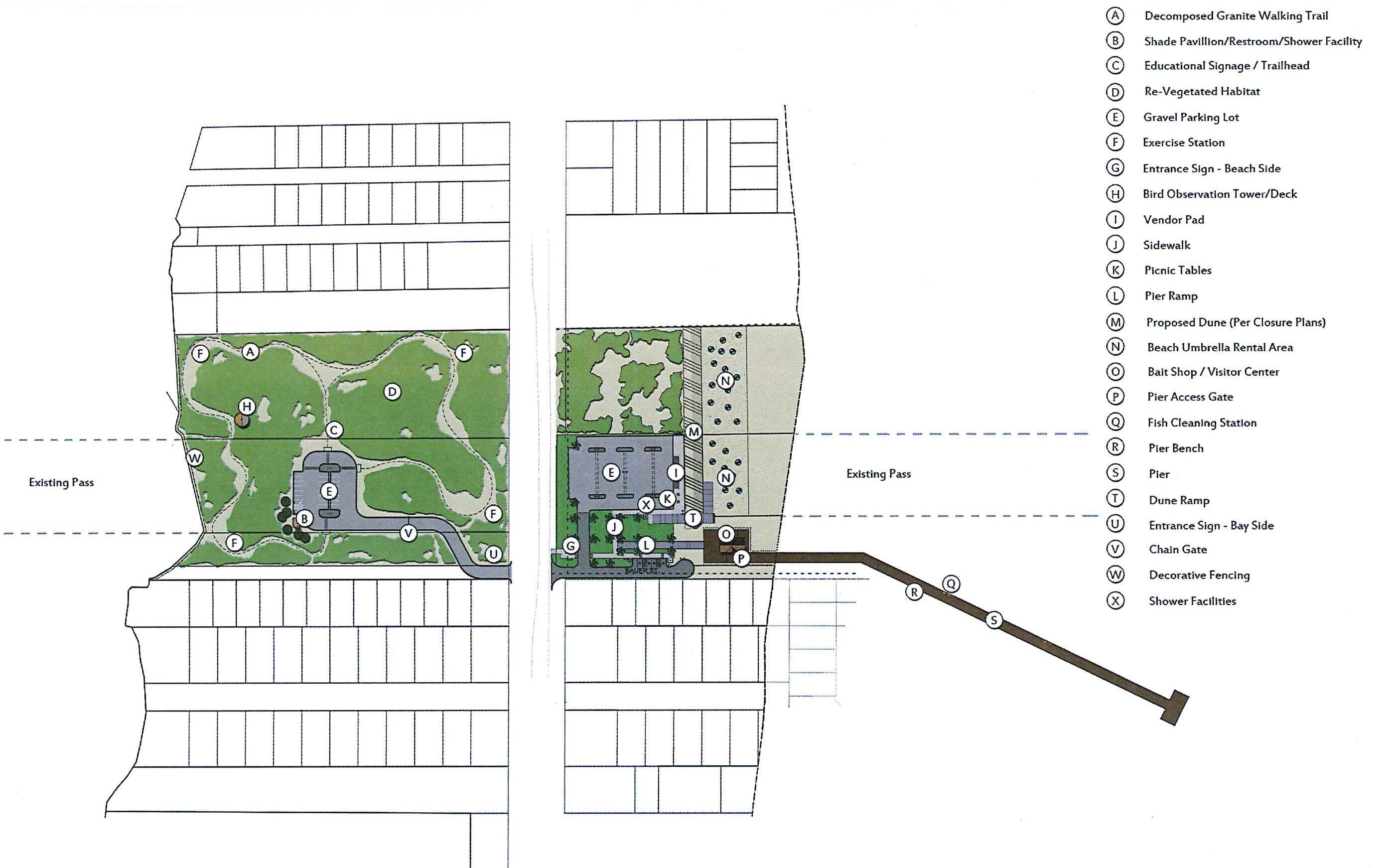
A very preliminary rendering of the proposed park is below.
What will the pier look like?
A fishing pier will also be built on the gulf side of the peninsula for fishermen and everyone who enjoys the gulf to have for generations to come. A very preliminary rendering of the proposed pier is below.
When will the park be finished?
Estimated deadline for park competition is December 2022.
Who authorized the closure of the pass?
The Texas Legislature and Governor Rick Perry approved funding to close Rollover Pass in 2009. Following the devastation of Hurricane Ike, the 81st Texas Legislature authorized the GLO to “undertake the modification or closure of a man-made pass or its environs between the Gulf of Mexico and an inland bay” if the Commissioner determines “that the pass causes or contributes to significant erosion of the shoreline of the adjacent beach.” (81st Leg., ch. 66, §1, eff. Sept 1, 2009).
Former Land Commissioner Patterson made this public determination in December 2011. Among other problems, exhaustive studies have shown that Rollover Pass significantly contributed to erosion on Bolivar beaches, posed health and safety risks, threatened the Gulf Intracoastal Waterway, and costed taxpayers hundreds of thousands of dollars in maintenance costs each year.
Park Renderings

Additional Resources
- 2019 Permit Application to USACE for Pier at Rollover Pass
- Analysis of Impacts from Rollover pass to Adjacent Beaches & the Littoral System
- Determination Memo Regarding Rollover Pass — December 2011
- Summary of Erosion and Hazards-related Issues — Rollover Pass — December 2011
- Recreational Amenities Plan for Rollover Pass — December 2011
- Rollover Pass Permit Application
- Request for additional information from U.S. Army Corps of Engineers
- Response to February 4, 2010 Request for Additional Information Letter
- Draft Environmental Assessment and Associated Attachments
- U.S. Army Corps of Engineers Public Notice
- Plans for Rollover Pass — February 2010
- Rollover Pass Presentation — February 6, 2010
- Hydraulics and Stability of Tidal Inlets
- Rollover Pass: Why closing it is the right thing to do
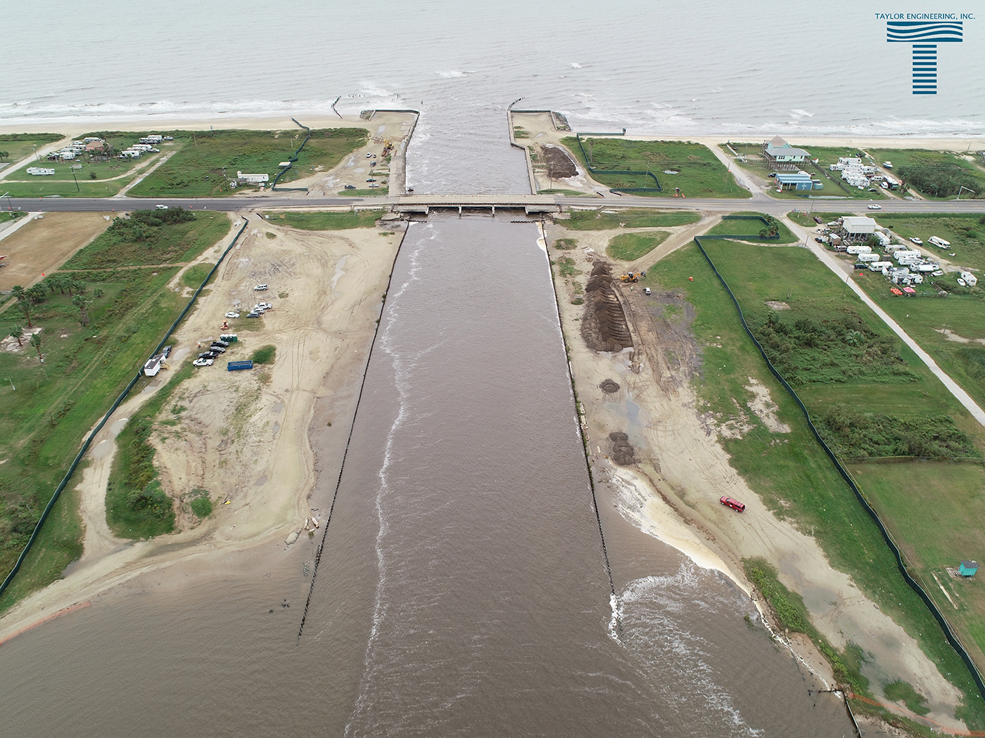
Before:

Drone footage capturing the erosion occurring at Rollover Pass before the construction began
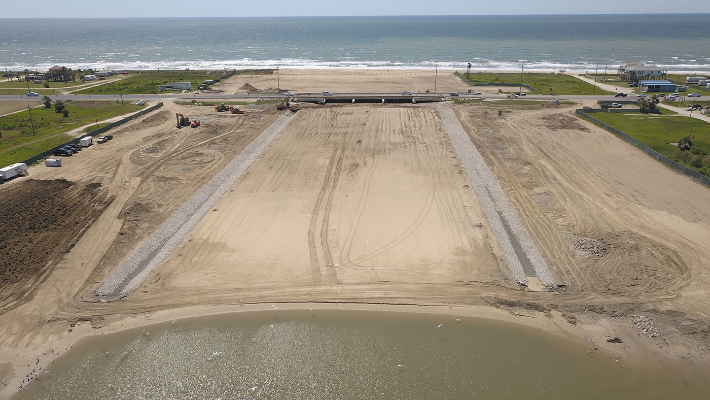
Current Progress:

Updated footage of Rollover Pass closure as of April 24, 2020.
