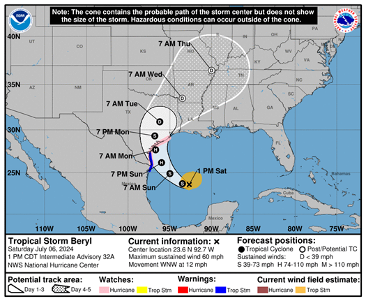
Today Texas Land Commissioner Dawn Buckingham, M.D. announced that the Texas General Land Office (GLO) continues to monitor the changing intensity and path of Beryl, which is currently a tropical storm but expected to intensify into a hurricane before making landfall along the Texas coast. Current predictions have the storm’s path following the coastline with the exact landfall uncertain at this time. Impacts are expected along the entire coasts and the risk of rip currents, storm surge, and inland flooding should be taken seriously by all Texans inside or near the “cone of concern”.
"The GLO has elevated the readiness of all our divisions to assist Texas communities in Beryl’s path," said Commissioner Buckingham. "I urge all Texans to take the appropriate precautions to keep your family and neighbors safe including remaining alert to local weather predictions and heeding warnings from local officials."

According to official reports, Beryl’s structure seriously degraded while passing over the Yucatan Peninsula, but the storm will gradually begin to intensify later today while continuing to pass over the Gulf of Mexico where conditions will be favorable for intensification right through landfall. The GLO recently reported on activation of readiness procedures in anticipation of helping communities in the storm’s path.
The GLO encourages Texans to follow the following preparedness tips:
- Monitor storm systems in the Atlantic and Gulf of Mexico. Watch local news and follow the National Hurricane Center on Twitter and Facebook.
- Review your Disaster Evacuation Checklist and have your “Go Bag” ready in case of evacuation.
- Know your available evacuation routes and review them with your family. Be sure to plan multiple routes and be ready for potential road closures.
For additional safety tips related to storm surge, flooding, and other dangers, visit recovery.texas.gov/preparedness.


